

OpenStreetMap-3D
Integration of OpenStreetMap and Digital Elevation Model and their use by means of interoperable GI-Web Services
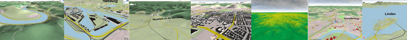
In the context of the research project Geodata Infrastructure 3D the open geodata of OpenStreetMap (OSM) and the elevation data of the Shuttle Radar Topography Mission (SRTM) were used for the development of a 3D Geodata Infrastructure (GDI-3D) for entire World based on open web service standards of the Open Geospatial Consortium (OGC). A Web 3D Service (W3DS) is providing the processed data as a 3D scene graph to the client. The visualization of the OpenStreetMap data in 3D takes place in a 3D Viewer (XNavigator), which was developed for displaying the data provided by the W3DS. In contrast to server side rendered maps (if 3D or 2D as in typical Web Map Services (WMS) like www.osm-wms.de) a completely free client side interaction and navigation is possible. As all data is passed to the client computer, where it is rendered, a good internet connection and recent computer with its own graphic card are needed. Therefore this method is also especially suitable for intranets.
The Project "OSM-3D Globe" is accomplished by: |
|
|
Research group GIScience, Prof. Zipf |
2012 University of Heidelberg, Department of GIScience, GIScience